Courtesy of the Folks at NEON
Courtesy of Leica Geosystems – Chapter 2 of 3 – Tripod based LiDAR
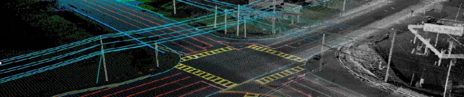
Courtesy of Amar Nayegandhi at Dewberry
Please check out this video from my colleague and friend Amar. He explains LiDAR very well in this video. Below the video, there is a Youtube link to the series of videos by Amar and Dewberry.
The following is courtesy Greg Lennon as a result of his comment provided.
LiDAR Wikipedia
The National LiDAR dataset
More on LiDAR


Jamie,
If you’re looking for a topic to blog about (or even just mention), I’d appreciate it if would call attention to the Wikipedia pages about LiDAR, and especially the page I started to compile all known US counties (and even states) with fully available, high resolution (~1-2m posting) LiDAR data. [This page.]
My hunch is that those readers of your blog who don’t already know about this page will find it of interest, and of course, I also hope that if any of your readers know of counties that should be listed they’ll either add them directly to the page or will speak up to ask someone else to add them.
One other topic to consider: near-ground (within 2 meters) vegetative classification, especially using open source or readily available software. It’s an interesting topic that like many “extractive” abilities seems to be coming along nicely and be of increasing use to many folks.
Regards,
Greg Lennon, Red Arrow Maps
And also: Lidar Links for Mappers